Historic Neolithic Monument
Sandy Gerrard Preliminary Report 19th
February 2012
The Mynydd Y Betws prehistoric landscape and the wind farm
In
recent
days much has appeared in the press about the stone row on
Mynydd Y Betws. Some of the reporting has been slightly
inaccurate and this may in part be a result of a
misunderstanding of the character of the archaeology and
development on the mountain. The development is vast, extending
over 5km from end to end and the discussions have centred around
a relatively small area on the slopes of Bancbryn along which
the stone row runs.
Over the past few days I have been carrying
out
a rapid
survey
of the remains in this small area using a hand held GPS unit.
The result is a map showing in broad terms the character and
disposition of archaeological remains in the vicinity of the
row. I have spent only about two full days in the field and
further work will inevitably enhance the results.
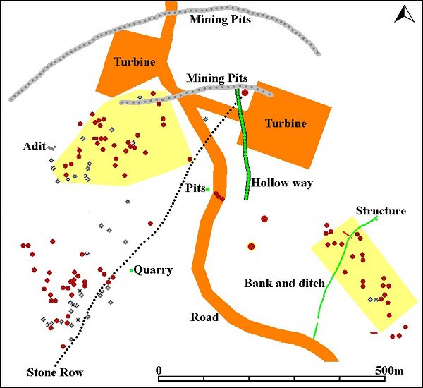
Hopefully
the
map highlights why I am concerned that permission was granted to
build the wind farm without any earthwork survey being
conducted.
The
map also shows (in yellow) the position and extent of the
scheduled archaeology. The scheduling mapping is based on the
maps submitted with the planning application and may not be
entirely accurate, but hopefully gives a helpful insight into
the extent of nationally important designated archaeology at the
time when the planning permission was granted. The mounds on the
map are shown in two different colours. The pink mounds have no
associated hollow and are therefore most likely to represent
cairns. The grey mounds have an associated hollow and therefore
may be prospecting pits, the result of trees being blown over or
less likely, barrows.
These
earthworks
are not of uniform size or character and may therefore owe their
origins to a variety of causes. Perhaps of significance is that
they are generally associated with structures that do look like
cairns. Perhaps work in the future will provide clarification or
at least some further clues. Anyway, there are a large number of
mound type earthworks and broadly they fall within three main
clusters with occasional outliers. To all intents and purposes
this looks like an important ceremonial/ritual landscape with
the stone row forming its focus.
This
impressive landscape now has a large road cutting right through
its heart and shortly will have two substantial wind turbines
towering 110m above it. The proximity of these two turbines to
the scheduled area clearly illustrates that archaeology
is
not safe from
this
new threat to upland archaeology.
The
setting of this significant landscape will be compromised for
years to come and even after the turbines have been dismantled
the archaeology lost in their construction will be gone for
ever. It is just not possible to replace archaeology once it has
been destroyed and for this reason and quite rightly so there
are legal constraints in place to ensure that archaeology is
recorded before it is destroyed.
This
has not happened at Mynydd Y Betws. No earthwork survey was ever
conducted and as a result archaeological remains of many periods
have been lost before they could be recorded. Some form of hurried
last
minute
archaeological
excavation work was carried out on the stone row before the road
was built and the results are awaited with interest. This is
very reminiscent of the “bad old days” when archaeologists were
granted a short time to scrabble about as the bulldozers hovered
with
their engines revving nearby. A survey
of
the area would have surely avoided this situation.
Interestingly
the
Evaluation Report would seem to indicate that a trench was cut
across the line of the stone row, but nothing was found. This
same trench was also close to the obvious linear hollow labelled
on the map as a hollow way. Given that a length of this
earthwork was going to be destroyed by the new access road why
was no trench actually placed across this very obvious earthwork
and instead positioned on apparently level ground next to it?
The same question should be asked of another trench that was
placed on level ground next to the three cairn-like
features
within the development area?
A further linear bank and ditch earthwork of historic type to the south of those mentioned above has also been cut through by the road and is clearly visible in the section formed by the newly constructed road ditch. An evaluation trench was excavated in this location, but there is no specific mention in the report of a ditch and bank even though these features are now clearly visible in the road cutting. Why was the trench not excavated on the site of the earthworks?
A large amount of documentation relating to the pre-construction archaeological aspects of this development can be found at http://online.carmarthenshire.gov.uk/eaccessv2/ This makes very interesting and enlightening reading and confirms that despite the richness of this landscape no attempt was ever made to look for surface remains. The reference number you need to enter is E/10446. Then click the documents tab at the top. This will reveal 6 pages of tables of linked information.
The most useful ones are:
E.S. VOL 3: FIG 18 ARCHAEOLOGY MAP FINAL
E.S. VOL 2: APPENDIX F – ARCHAEOLOGY
ENVIRONMENTAL STATEMENT: VOLUME 2 WRITTEN STATEMENT
Written Scheme of Investigation ~ August 2010
Archaeological Evaluation ~ March 2011
Archaeological Watching Brief
Taken together these papers provide a clear explanation of why archaeological remains in the area were not fully taken into account during the planning process and why the subsequent Scheme of Investigation failed to identify important archaeology within the development corridor. I hope you now appreciate why I feel that this important archaeological landscape has been sadly neglected.